A snapshot of the Hawaii mesh — nodes across Oʻahu, Molokaʻi, Lānaʻi, Maui and the Big Island, with LoRa links (blue) bridging the channels between islands. Nodes report on the LongFast channel and bridge to MQTT under the msh/US/HI topic.
[ Overview ]
Hawaii has an active Meshtastic mesh — a volunteer, no-fee,
no-infrastructure LoRa network whose nodes find each other on the air and relay
text for the whole island chain. The map above is a snapshot of it: independent
nodes on each major island, plus LoRa links reaching clean across the channels
between them.

A few things the map tells you:

  — It spans the chain — nodes on Oʻahu, Molokaʻi, Lānaʻi, Maui, and the
    Big Island all show up on one mesh.
  — Everyone's on the LongFast preset — the default long-range channel.
    Sharing one preset and channel is what lets the nodes hear each other.
  — Internet-connected nodes bridge to MQTT under the msh/US/HI topic,
    which is how a map like this is assembled and how distant parts of the mesh
    stay visible to each other even without a direct RF path.

None of it needs a cell plan, a subscription, or permission. A node, an antenna,
and a good location is the whole price of entry.
[ Inter-island links over open water ]
The striking part of the map is the links that cross open ocean —
Oʻahu to Molokaʻi to Maui, and the long hop down to the Big Island. Those
channels are tens of kilometres of water, well past what you'd expect from a
low-power 900 MHz radio. They work for two reasons:

  — Over-water propagation carries. A sea path has no terrain to block
    it and a smooth, reflective surface; signals routinely reach far beyond
    plain line-of-sight, and atmospheric ducting over warm water can stretch
    them further still. This is the same effect that makes coastal planning
    tricky — see the maritime gotcha in the coverage-planning guide.
  — The endpoints are high. Inter-island hops live or die on antenna
    height and a clear horizon. A node on a ridge or a volcano shoulder with
    nothing but ocean in front of it can see another island's high node from
    enormous range. Down at sea level the same link simply doesn't close.

So the long blue lines aren't magic — they're high sites pointed at each
other across water that happens to be an ideal RF path. They're also not
guaranteed: lose the high endpoint (or the weather changes the duct) and the
hop drops. That's why the mesh leans on several routes, not one heroic link.
[ Real nodes on the mesh ]
I run a handful of nodes on this mesh myself. The ones below aren't them —
they're public nodes from the live map, picked because they're sited and
equipped so differently yet all reach across open water. Between them they run
three of the boards the build guide covers — a dedicated STATION_G2 router,
nRF52 RAK4631s, and an ESP32 Heltec V3 — from a 1,000 m peak down to the coast,
all on the default LongFast channel.
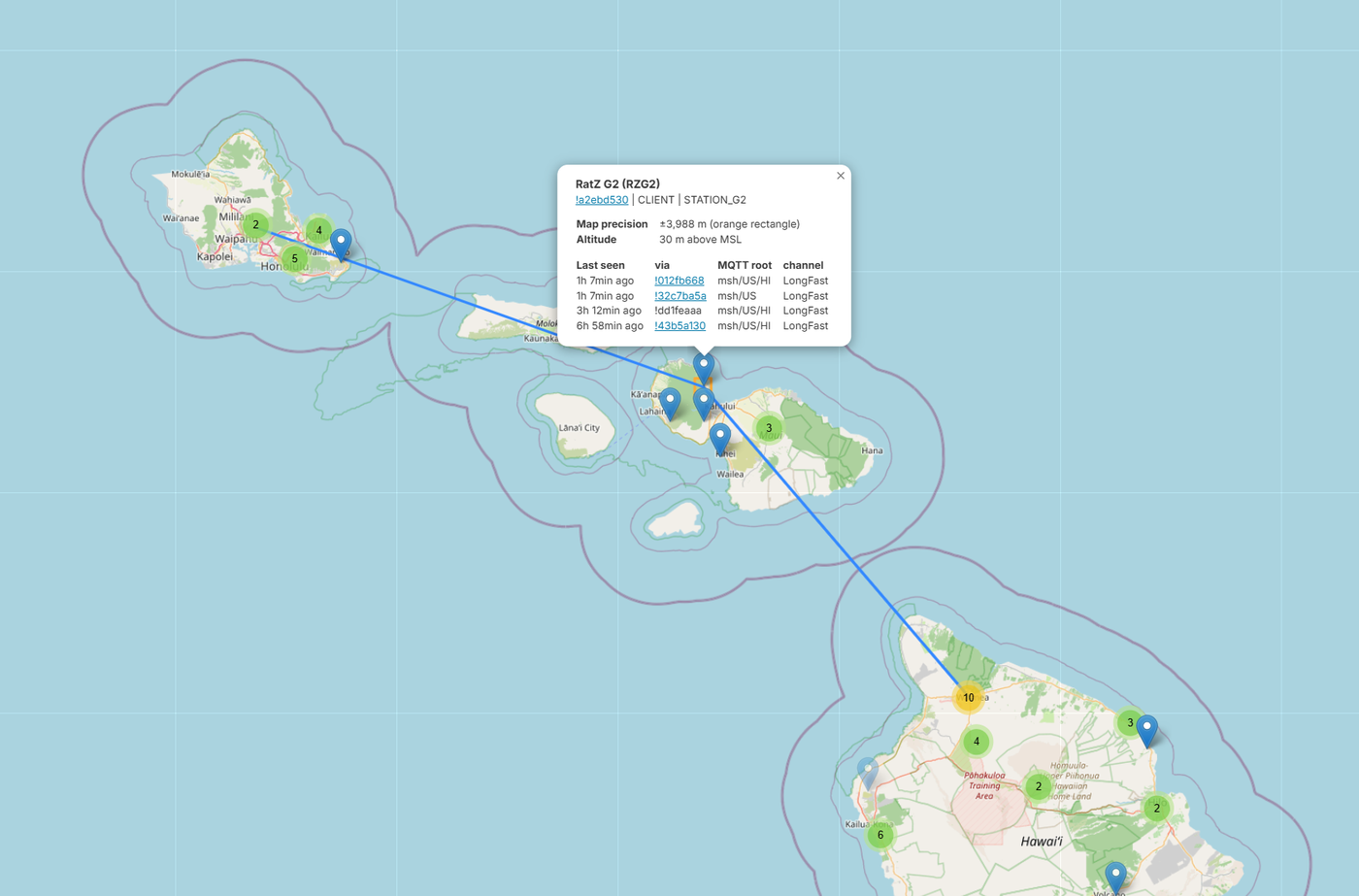
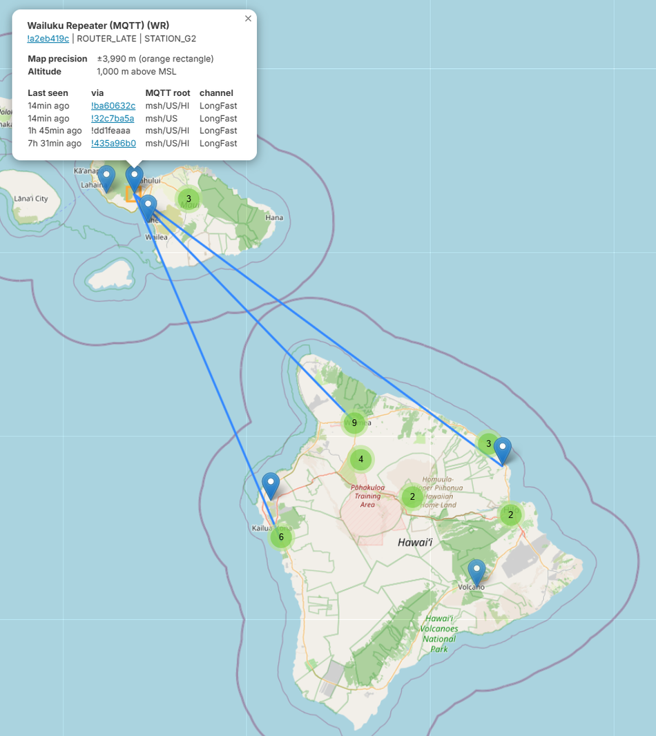
Wailuku Repeater — Maui, ~1,000 m above MSL. A true high site, equipped like one: a STATION_G2 router board on the ROUTER_LATE role, MQTT-bridged, fanning links across to a cluster of Big Island nodes.
The backbone. At ~1,000 m it has the horizon to reach a whole cluster of nodes
on the Big Island at once, and it's built for the job: a STATION_G2 (a dedicated
router board) on the ROUTER_LATE role, bridged to MQTT. It's the textbook
infrastructure node from the build guide's roles section — high, dedicated, and
deliberately ROUTER_LATE so it relays without stomping the primary routers.
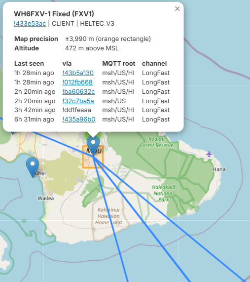
WH6FXV-1 “Fixed” — Maui, ~472 m above MSL. A callsign-named fixed node on a plain Heltec V3 (ESP32) that's one of the better-connected spots on the mesh — its packets reach the map via six different gateways.
Cheap hardware, good spot. The name says it — a fixed, stationary node —
running on a Heltec V3, the ~$15 ESP32-S3 starter board. ESP32's thirsty
sleep current doesn't matter at a powered fixed site, which is exactly when the
build guide says reach for a Heltec instead of an nRF52. At ~472 m and well
positioned it's heard widely — the map shows it arriving via six separate
gateway nodes. Placement and uptime beat exotic gear.
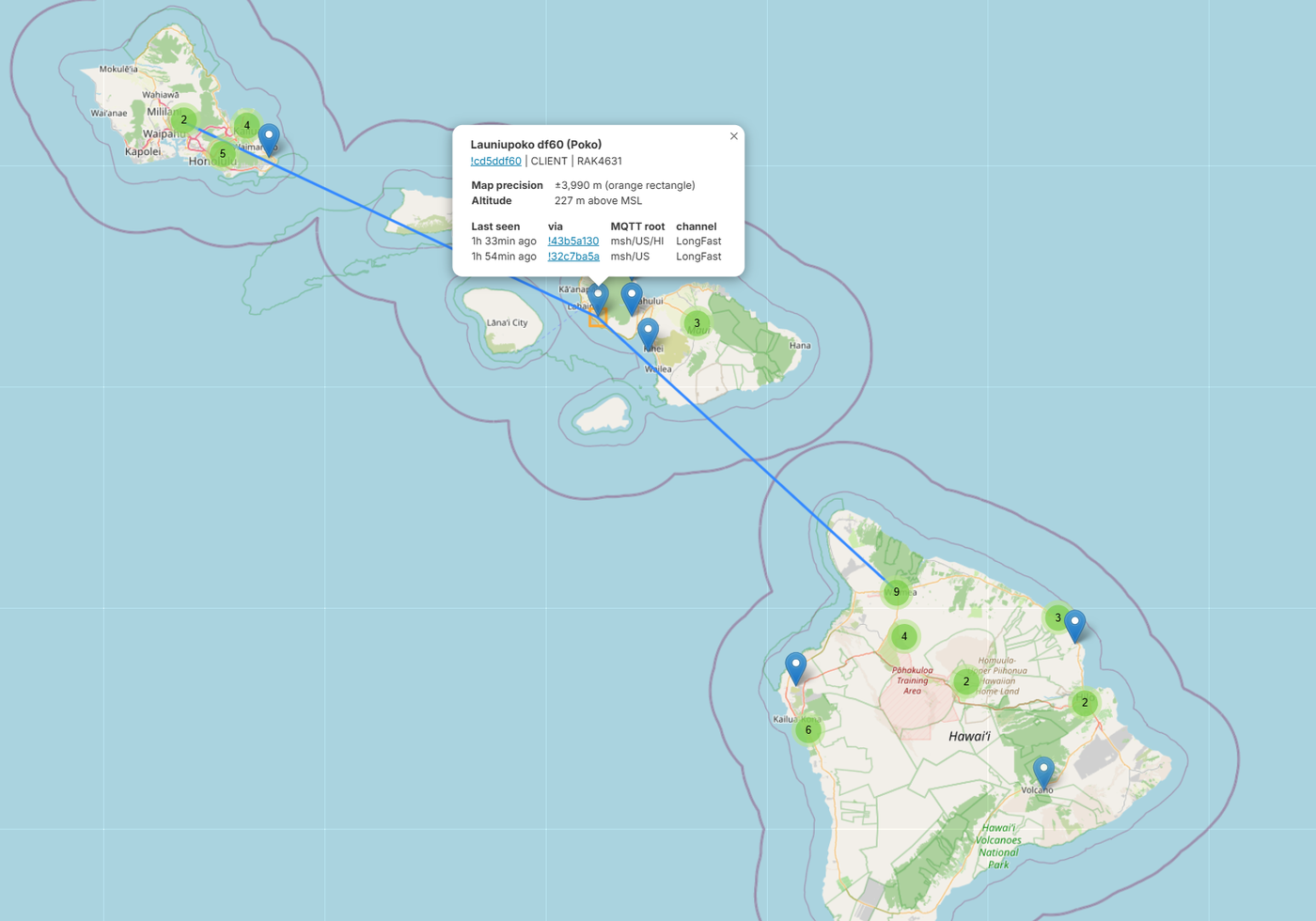
Launiupoko “Poko” — West Maui, ~227 m above MSL. A mid-slope relay with a clean ocean horizon — enough to link across to Oʻahu and down to the Big Island.
Lower and lighter than the Wailuku router, but it still reaches two other
islands. At ~227 m on the West Maui slopes it has open water in two directions,
which is what makes the long over-sea hops in the section above close. It's a
RAK4631 (nRF52) on the plain CLIENT role — which still rebroadcasts — showing
you don't need dedicated router hardware to be useful from a decent height.
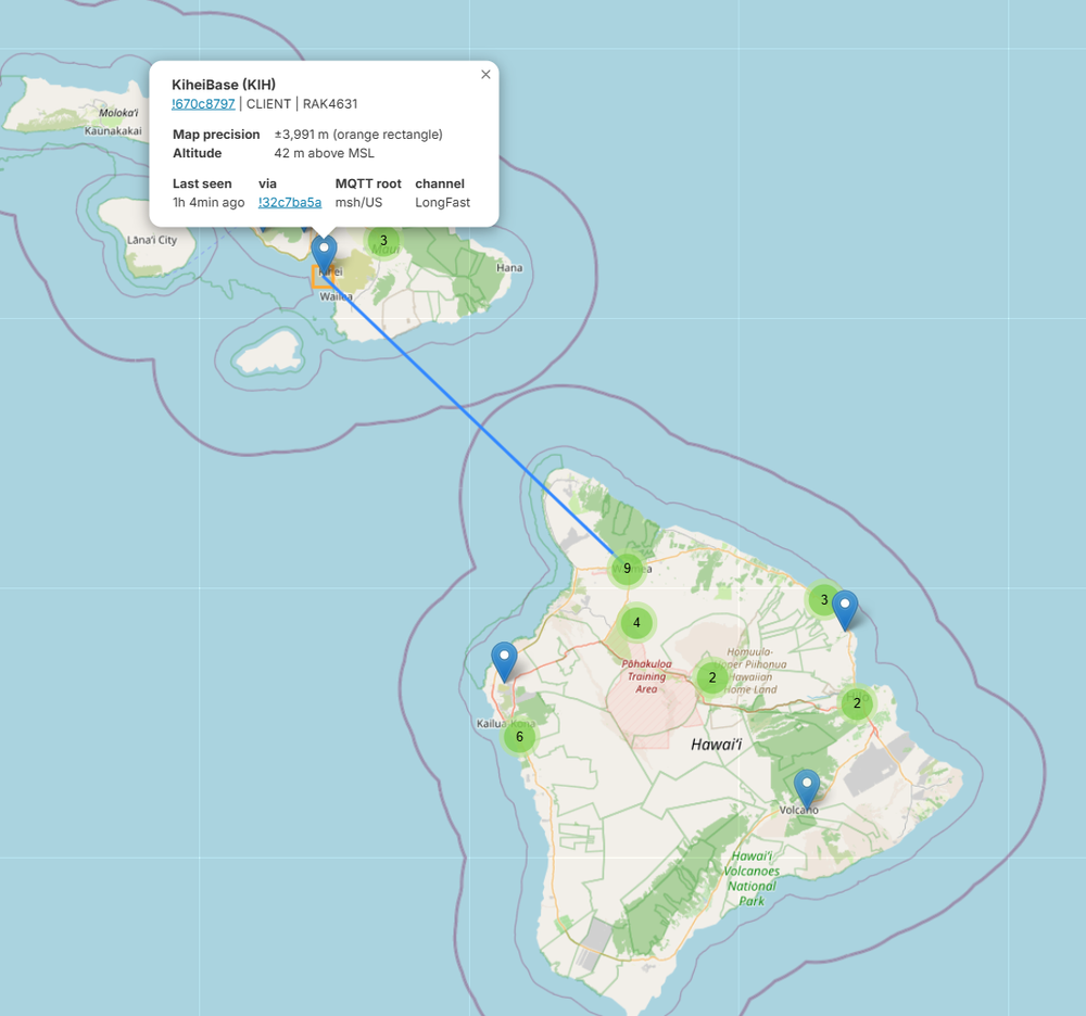
KiheiBase — Kīhei, South Maui, ~42 m above MSL. A low coastal node that still makes the long over-water hop south toward the Big Island.
The low counterpoint. Down at ~42 m on the South Maui shore it's no hilltop, but
a flat, unobstructed shot straight out over the water still carries it toward the
Big Island. Another RAK4631 on LongFast — proof that when terrain isn't in the
way, even a modest sea-level node reaches a long way over open ocean.
[ Get on the mesh ]
Joining is the same anywhere — Hawaii just happens to have the geography that
makes it fun:

  1. Get a node. Any Meshtastic-supported LoRa board for the US (915 MHz)
     band. Buy one or build one — see the node build guide.
  2. Set the region to US and leave the preset on LongFast so you're on
     the same channel as everyone else. (A node that ships UNSET won't transmit
     until you pick a region.)
  3. Put it somewhere with a view. Height and a clear horizon beat power every
     time; a window facing the right direction can be the difference between
     hearing the mesh and hearing nothing.
  4. (Optional) bridge to MQTT. A Wi-Fi-capable node pointed at the
     msh/US/HI topic puts you on the shared map and links you to parts of the
     mesh you can't reach directly over RF.

That's it — once you're on LongFast in the US region and within earshot of any
node, you're part of the mesh.
[ Build & plan ]
Two companion guides cover the how-to in depth:

  — Meshtastic Node Build
    — choosing the board (low-power nRF52 vs Wi-Fi-capable ESP32), the antenna
    details that decide your real range, solar power for remote relays, and
    picking the right mesh role.
  — Meshtastic RF Coverage Planning
    — model where a node will actually reach before you climb the hill,
    including the maritime-climate setting that makes or breaks over-water and
    inter-island predictions.

For a high relay aimed across a channel, both matter: the coverage planner picks
the site and proves the path, the build guide gets a node that survives up there
on its own power.